B4 Data

-Click on photo for high resolution version-
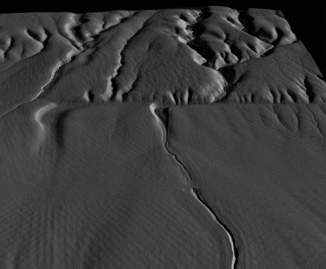 Wallace Creek, San Andreas fault in the Carrizo Plain - B4 Project LiDar 0.25 m DEM (Image courtesy: Dr. Kenneth Hudnut). Click here for more information on this project that was presented at the March Inland Empire Chapter meeting.
Here are some web links, ftp sites, etc. for the B4 data. For more details contact Ken Hudnut of the USGS, hudnut@caltech.edu
Start here for all of the meta data and web pages with extensive links:
http://www.earthsciences.osu.edu/b4/Site/Welcome.html
Or this one for links to the B4 KMZ files for Google Earth:
http://www.siovizcenter.ucsd.edu/topo/b4.php
If you just want to ftp that set of files, you can go straight to here:
ftp://topex.ucsd.edu/pub/B4_kmz [download all files, then load into Google Earth using the 'file' menu - select through 'open']
All of these are geared towards getting 1 m DEM's readily available through Google Earth, so as of now, the KMZ set is only at one meter.
In the future we hope to make the whole data set available this way at higher resolution, but even at 1 m it seems to bog down Google Earth a bit. So I would only try loading in one segment at a time on anything but a new superfast computer.
There is a uniform set of 0.5 m DEM's available here for most of the B4 project, and these are also avail. via the USGS "CLICK" interface.
ftp://pipeline.gps.caltech.edu/pub/users/hudnut/B4/B4_DEM_set/
http://lidar.cr.usgs.gov
If you want higher resolution, then I'd recommend using the GEON interface - there you can get the raw point cloud or use the free interface to generate custom DEM's:
http://www.geongrid.org/resources/data.html