FIELD Trips
AEG Inland Empire Spring Field Trip Announcement
Saturday - April 20, 2024
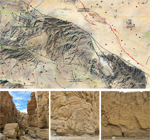
Anza-Borrego State Park: Split Mountain to Sandstone Canyon
Subsiding Basin/San Andreas Rift Zone/Colorado River/Mega
Landslide/Rockfalls/Topples/Debris Flows/Faults/Imperial Fm/Palm Springs Fm.
ALL TO SEE AND MARVEL
( SEE THE BROCHURE )
Date and Time: April 20, 2024. Approximately 8:00 am to 2:00 pm.
Location: Split Mountain Road at Fish Creek Wash, Ocotillo Wells, San Diego County, CA
Cost: Free, but your time and talent will be taken advantage of.
Trip will begin at the intersection of Split Mountain Road and Fish Creek Wash, south of the Ocotillo Wells offroad recreation area: Coordinates: 33.03964N/116.09696W. Meet in the wash at the west side of the road and carpool from there through Split Mountain and on to Sandstone Canyon. Trucks and high clearance vehicles only. 4x4 usually not required. Each attendee needs to bring their own snacks and lunch.
The excursion is intended to be somewhat informal with the objective to highlight the awesome geology of the Anza-Borrego, not to mention some seriously extreme geologic exposures and geologic hazards.
To sign up, please contact Mark Spykerman at mspykerman@earthsystems.com. Deadline to RSVP is April 13, 2024.
RSVP IS REQUIRED TO OBTAIN A GUIDE BOOK. Due to some topographic confinements, attendance will be limited to 30 maximum and carpooling in 7 to 8 vehicles.

2016 AEG Inland Empire Annual Spring Field Trip
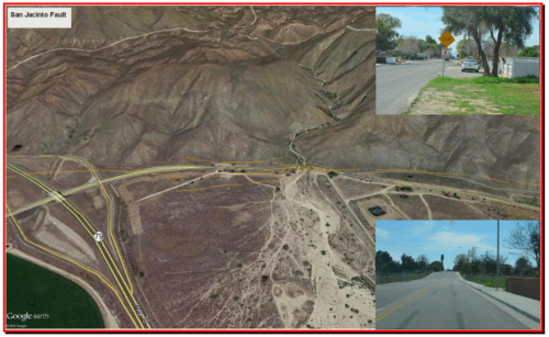
San Jacinto Fault Zone - Parks and Faults with Side Trip to Massacre Canyon
Saturday - April 30, 2016
Approximately 8:00 am to 1:00 pm
( SEE THE BROCHURE )
Location: San Jacinto Fault Zone in Hemet and San Jacinto, Riverside County, CA
Cost: Free, but your time and talent will be taken advantage of.
Field trip will begin at the Stater Bros. shopping center at the northeast corner of State Street and Ramona Expressway in San Jacinto (There is a Starbuck!!!). The first stop will be a short hike up Massacre Canyon near Gilman Springs Road and Hwy 79 (Sanderson Avenue). Fascinating geology with some historical highlights. The tour will progress along the San Jacinto fault zone/Casa Loma strand, through the Cities of San Jacinto and Hemet, looking at the local fault expressions, impacts on roadway alignments and urban development.
Speakers include:
Dr. Sally McGill of California State University San Bernardino
Ms. Janis Hernandez of the California Geologic Survey
Ms. Lisa Battiato of Geocon
Mr. Frank Jordan
The excursion is intended to be somewhat informal with the objective to highlight the often subtle fault expression within urban development. An added attraction is the awesome San Jacinto Mountain range front along the northeast side of the City of San Jacinto to ponder the geology, faulting and landslides.
Attendance will be limited to approximately six cars (approximately 24 people) for highway safety purposes. Drivers will be requested to arrive early to review planned stops. We will meet in San Jacinto and form a carpool to limit the total number of vehicles. Additional information will be provided at the next AEG meeting.
To sign up, please contact Mark Spykerman at mspykerman@earthsystems.com. Deadline to RSVP is April 20, 2016.
RSVP IS REQUIRED TO OBTAIN A GUIDE BOOK.
2015 Annual Chapter Field Trip
An Uplifting Experience: The Cajon Valley:
70 Ma of Textbook Geology
Saturday, May 02, 2015
( SEE THE BROCHURE )
WHAT WILL WE SEE?
Structures:
- The collision point of the Pacific and North American plates
- Rotation of Transverse Range blocks with accompanying basin filling
- San Andreas Fault and the Squaw Peak Fault
- Timing and sequence of uplift of San Gabriel and San Bernardino blocks and developing geomorphologic features such as sag ponds and terraces Stratigraphy:
- Cosy Dell Formation: Cretaceous, with elasmosaurs, fish, crustaceans, and mollusks
- Vaqueros Formation, Oligocene-Miocene, with dolphins, fish, and mollusks
- Cajon Valley Formation, Miocene continental biostratigraphy
- Crowder Formation, Miocene continental biostratigraphy, relation to Mojave drainage patterns
- Phelan Peak Formation and the rise of the San Gabriel Mountains
- Shoemaker Gravels, Old Alluvium, the Brunhes/Matuyama Reversal, and rise of the San Gabriel Mountains.
- Early Pleistocene drainage and reversals and the development of the Mojave River
2013 Annual Chapter Field Trip
Wildomar Fault, Elsinore Graben
and Development Challenges,
and Vulcan Quarry (Corona)
Saturday, May 11, 2013
2012 Annual Chapter Field Trip
Geology and Geologic Hazards and Other Cool Stuff Along Portions of Hwy 18 and Hwy 330
Saturday, June 9, 2012
Registration is NOW CLOSED as we have the maximum capacity. Registration was limited to the first 20 people (i.e. 5 vehicles) due to turnout space along highway. Additional information will be distributed to the registrants.Address any questions to: mspykerman@earthsys.com.
2011 Annual Chapter Field Trip
Water and the San Bernardino Mountains
The Good, The Bad and The Muddy
Saturday, April 9, 2011
RSVP by Wednesday April 6, 2011
The AEG Inland Empire Chapter's Annual Field Trip will occur on Saturday April 9, 2011. The focus will be on Water and the San Bernardino Mountains The Good, The Bad and The Muddy. Will be looking at and discussing major water projects situated along the San Bernardino Mountain front from the Santa Ana River to Cajon Creek including Seven Oaks Dam, Inland Feeder Project, Devils Canyon Power Plant. Also we will be reviewing the impacts from winter storms and fire burn hillsides. Stops include: review of fault trenching at Plunge Creek; Highland mud damage; and Boulder Avenue Bridge washout from the December 22, 2010 flooding; Cal State San Bernardino flood basins; and a tour of the Devils Canyon Power Plant.
- Meeting Point is in the Highland Avenue Plaza - Wal*Mart parking lot on the NW corner of Highland Avenue and Boulder Avenue (near the Burger King). Meeting time will be at 7:30AM so we can begin at 8:00 AM.
- Pre-registration is required due to requirements for the tour of Devils Canyon Power Plant.
Please notify Mark Spykerman (mspykerman@earthsys.com) or Mike Cook (MCook@kleinfelder.com) by April 6th if you are planning on attending.
Date & Time
Saturday April 17
7:30 am to ~1:00 pm
Schedule
Meet at 7:30 am at Menifee Market Place at Haun Road and Newport Road (TG Page, 868 E3). Staging area in parking lot in front of Breakfast Club.
RSVP by April 13
Contact Mark Spykerman at mspykerman@earthsys.com; list the number field trippers.
2009 AEG-Inland Empire Annual Field Trip
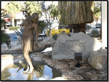
HYDROGEOLOGY OF THERMAL SPRINGS IN THE PALM SPRINGS AREA
- INDIAN CANYONS & AGUA CALIENTE HOT SPRING
Courtesy of the Aqua Caliente Band of Cahuilla Indians
|
WHEN:
|
MARCH 14, 2009
|
|
WHERE:
|
PALM CANYON, ANDREAS CANYON, AND AGUA CALIENTE HOT SPRING, PALM SPRINGS, RIVERSIDE COUNTY, CALIFORNIA
|
|
SCHEDULE:
|
Meet at 7:30 am at Agua Caliente Spa Resort Casino in Palm Springs located at northeast corner of East Tahquitz Canyon Way and Indian Canyon Drive (TG Page, 786 E2). Staging area in parking lot at northwest corner of Spa and Resort (Entrance at Andreas Road and NB Indian Canyon Drive)
General Schedule Of Trip:
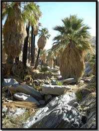
- Meet at the Agua Caliente Resort in morning and then carpool to Indian Canyon (tribal land).
- Hike up Indian Canyon to review the springs and related geology.
- Return to the Agua Caliente Spring for a brief walk around to see the spring (now currently under the street near the casino) and discuss the theory's on its manifestation, geology, and chemistry.
|
Download field trip announcement for more details
|
PICTURES FROM THE FIELD TRIP, click on image to enlarge. All photographs by Kerry D. Cato.
.gif)
Scot Stormo (Earth Systems Southwest & Co-field trip leader) discusses the hydrogoelogy of the springs that the City of Palm Springs were named.
|
.gif)
View to the south along Indian Avenue. Original natural location of the springs is presently under the middle of the highway.
|
.gif)
Location of the currently active springs is underneath the sidewalk.
|
.gif)
View to the N-NW of the City of Palm Springs from the parking lot of the Indian Canyon's Park.
|
.gif)
View to the W, from the Indian Canyon Park parking lot, of Palm Canyon Creek and the native California Palms.
|
.gif)
Agua Caliente tribal ranger, and Mark Spykerman (Earth Systems Southwest & Co-field trip leader) listen to Dick Brown discuss nearby area where he did his UC-Riverside Master's thesis.
|
.gif)
Although there is a lighologic change from igneous rock (on the left) to metamorphic rock (on the right), our group did not find a fault in this location.
|
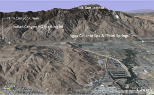
View west across upper Coachella Valley at the east flank of San Jacinto Mountains. Image shows the 2 field trip stops: at the south is Palm Canyon and at the north is the Aqua Caliente Spa and location of the Palm Springs. The San Gabriel Mountains and part of the San Gorgonio pass can be seen at upper right of photo. (Graphic by Google Earth)
|
|
2008 AEG-Inland Empire Annual Field Trip
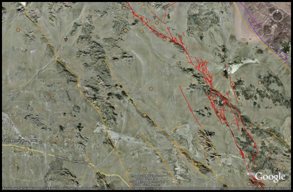
The Emerson Fault, 16 Years Later
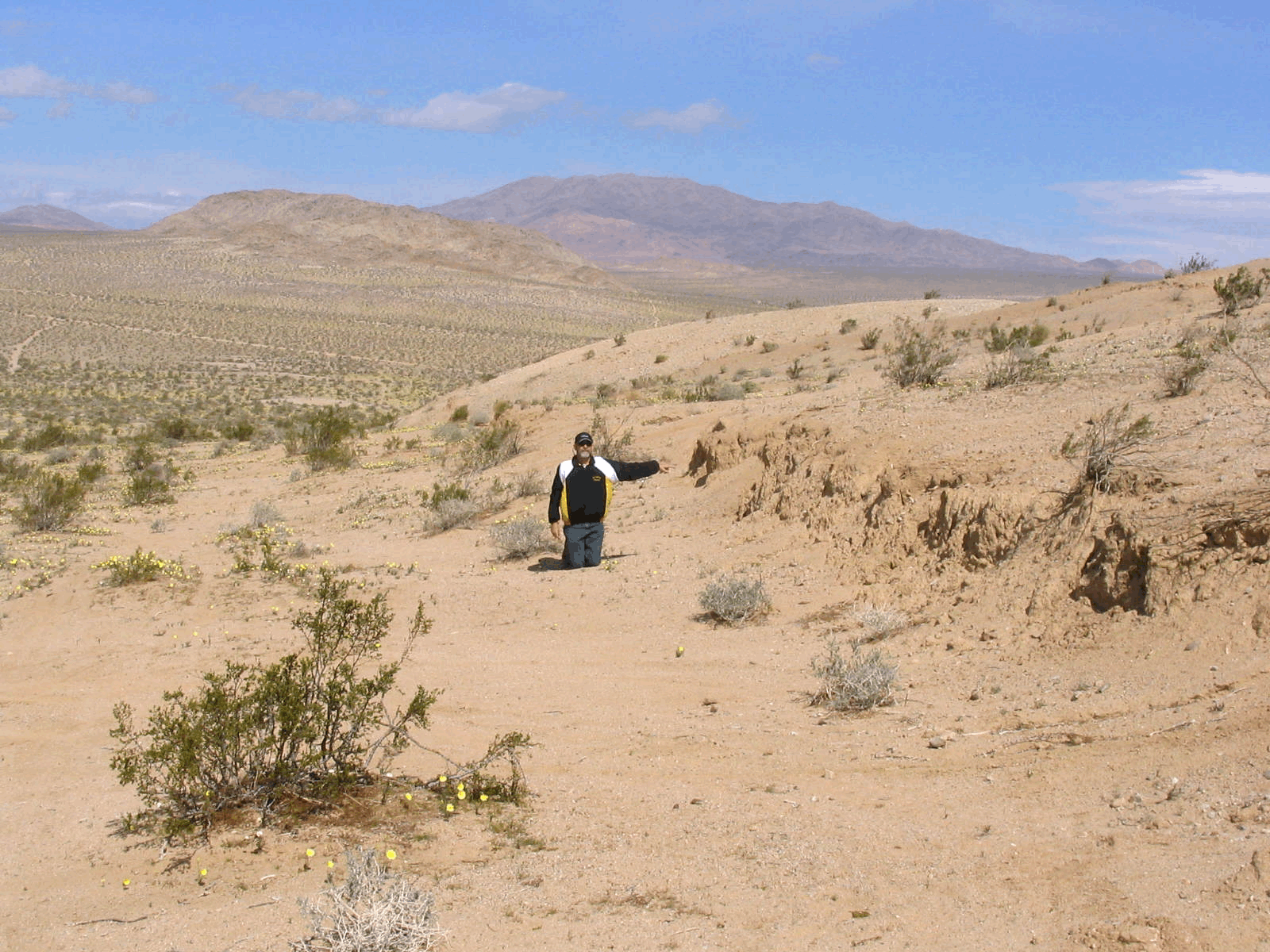
On Saturday April 5th, an informal field trip was successfully convened by 8 intrepid explorers, thanks to Mark Spykerman, Chapter Field Trip Chairman. We enjoyed a wonderful weather day in the upper Mojave Desert amidst Spring wild flowers, desert tortoise, and spectacular vistas. Participants, exploring The Emerson Fault, 16 Years Later, included Michael Cook, Kleinfelder West, Redlands; Dale Hamelehle, Kleinfelder West, Redlands; Michael Watson and wife Katrina Watson, The Planning Group; Alexander Schreiner, Earth Systems Southwest, Bermuda Dunes; Joey McKinney and son Quinn McKinney, Earth Systems Southwest, Rancho Cucamonga; and Mark Spykerman, Earth Systems Southwest, Rancho Cucamonga.
| WHEN: |
APRIL 5, 2008
|
| TIME: |
8:00 AM TO 2:00 PM (After 2:00 pm, participants are free to roam the area on your own)
|
| WHERE: |
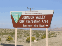
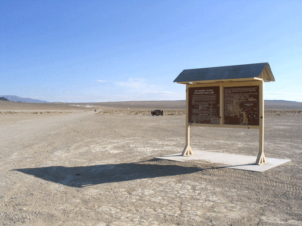
JOHNSON VALLEY OHV AREA, SAN BERNARDINO COUNTY, CALIFORNIA
|
| SCHEDULE: |
Meet at Soggy Dry Lake OHV staging area off of Bessemer Mine Road:
|
Directions to Staging Area:
- Take Hwy 247 (Old Woman Spring Road) to Bessemer Mine Road. Intersection is at:
- Thomas Guide Page 4483 H-5
- 34.4116N, 116.7234W
- Geologic Note: Old Woman Springs fault is just southwest of Hwy 247 and the intersection.
Intersection of Hwy 247 and Bessemer Mine Road
- Travel northeast on Bessemer Mine Road (dirt) about 3.1 miles to Soggy Dry Lake.
- Geologic Note: Cross Lenwood fault zone at mile 2.5.
- Meet at 8:00 am at the Johnson Valley OHV kiosk at Soggy Dry Lake. Stage just north of the kiosk and restroom on east side of Bessemer Mine Road, just east of Soggy Dry Lake.
- Staging Area Coordinates: 34.4432N, 116.6861W. Look for red Ford F150 Crew Cab.

Kiosk at Soggy Dry Lake Staging Area
|
NOTE: Vehicle access may be restricted to 4x4's. Entry road to Soggy Dry Lake OHV area is rough but accessible to cars (go slow). Bessemer Mine Road from Soggy Dry Lake to Emerson fault area generally passable for cars (trucks and 4x4's recommended). Trail off Galway Lake Road to area of maximum fault rupture is 4x4 recommended due to loose sand in wash. We recommend that participants truckpool at the staging area to reduce the overall vehicle traffic. ATV's are welcome.
Please RSVP by April 2, 2008 to Mark Spykerman at mspykerman@earthsys.com. List number of field trippers to attend please.
Bring your own lunch and refreshments. Select drinks will be provided by AEG.
|
2006 AEG-Inland Empire Annual Field Trip
Pushawalla/Thousand Palms SAF Field Trip
|
|
- Click to see image of field trip area
|
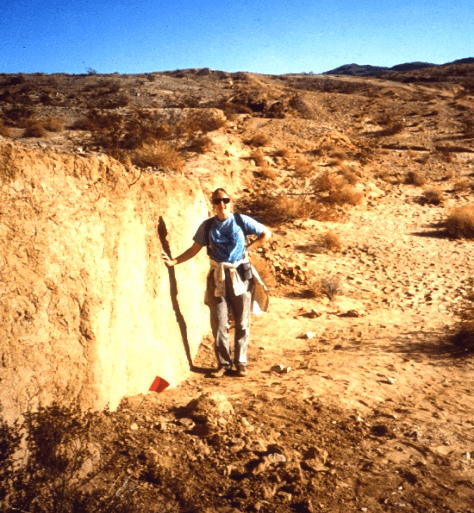
This field trip to see landforms and fault trenches near the San Andreas fault was held on Saturday April 22, 2006. It was led by Mark Spyckerman and Rick Gundry. The chapter plans to run several, small, one-day field trips throughout the year.
- See pictures from this fieldtrip by clicking on the thumbnails below (Photos by Mike Cook).
_thumb.jpg)
_thumb.jpg)
_thumb.jpg)
_thumb.jpg)
_thumb.jpg)
|
|
.jpg)
.jpg)
.jpg)
.jpg)
.jpg)
.jpg)
.jpg)


.jpg)
.jpg)
.jpg)
.jpg)
.jpg)